Urgent Storm Alert: 72-Hour Outbreak Set to Hit Australia – Key Facts
Unpredictable Weather Conditions Across Australia
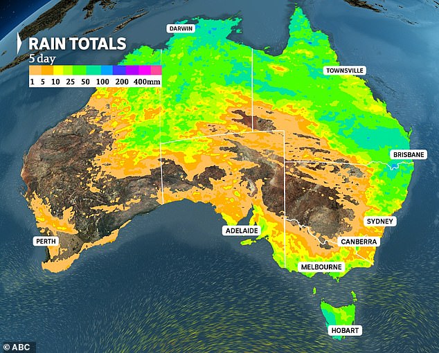
Australia is bracing for a series of unpredictable weather conditions this weekend, with thunderstorms expected to impact various regions across the country. The weather system is driven by tropical moisture that is spreading throughout the nation, leading to the formation of potentially dangerous supercells along the eastern seaboard. These storms are likely to be most severe in the areas closest to the coast, particularly from Friday through to Sunday.
The situation is further complicated by the presence of a northerly airstream that is bringing tropical air towards the southern states. This means that the areas of concern will range from the northern tropics down to western Victoria. Thunderstorms could even stretch as far south as Tasmania, indicating a wide geographical spread of the weather event.
Potential for Severe Storms
One of the major concerns for authorities is the threat of supercell storms over the heavily populated east coast. These storms can last for hours and move slowly, causing significant damage through heavy rainfall, damaging winds, and possible hail. On Saturday, the supercells are expected to affect southern Queensland, southeast New South Wales, and eastern Victoria.
Brisbane, being the capital most likely to be hit by severe weather on Saturday, is expected to face the brunt of the storm. Sydney and Canberra are also at risk, with the weather conditions potentially lasting into Sunday before some relief is experienced at the start of the working week.
Unseasonal Weather Patterns
Interestingly, there is a possibility of snowfall in the southeastern states, which is an unusual occurrence during this time of year. This is due to the movement of polar air from Antarctica, which is expected to reach Australia as summer approaches. A cold front is set to bring in the next wave of polar air on Sunday, affecting Tasmania, Victoria, and South Australia. This could lead to temperatures dropping by as much as seven degrees below average and bring alpine snow to the southeast ranges.
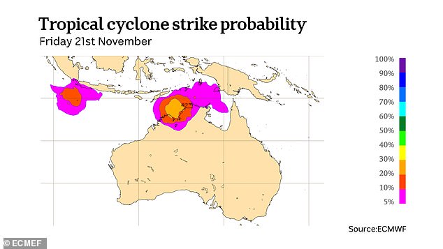
Cyclone Season Outlook
The current water temperatures off the northern coastline are up to two degrees above average, which could lead to an early start to Australia's cyclone season. This environment presents ideal conditions for a low-pressure system to form and deepen in the Timor Sea next week. However, the Bureau of Meteorology has predicted that there is only a 10 per cent chance of this system developing into something resembling a cyclone from Tuesday to Thursday.
Key Questions About the Upcoming Weather
As the weather continues to evolve, several key questions remain about the potential impact on different regions:
- What record-breaking weather changes are predicted to hit Australia’s bustling east coast this weekend?
- Could Australia face an unprecedented five cyclones hitting its shores at once this weekend as tropical storm threats loom for the north?
- Will northeast New South Wales, southern Queensland, and Northern Territory face the most intense storms this weekend due to a powerful inland trough?
- Is Australia bracing for a weather onslaught as severe storms rage across the country?
- Is the menace of thunderstorms set to wreak havoc across Sydney, Brisbane, and beyond this weekend?