Arctic Chill to Freeze 155 Million Americans as Temperatures Drop to 15°F
Unprecedented Cold Sweeps Across the United States
More than 155 million Americans are currently under weather alerts as an Arctic blast moves from the Midwest to the Northeast, bringing with it some of the coldest temperatures in recent memory. Meteorologists have warned that this cold front will bring record-breaking low temperatures across several states, impacting both daily life and local ecosystems.
Record-Breaking Temperatures
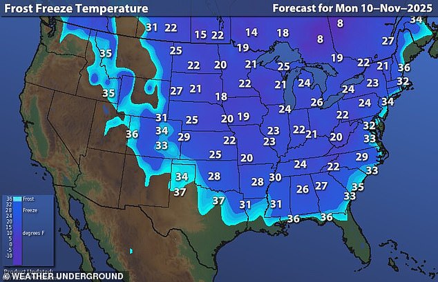
The lowest temperatures are expected to hit parts of North Dakota, Minnesota, Wyoming, and West Virginia, where the mercury could drop to a chilling 15°F this week. Several cities may break their daily cold records, including Huntsville, Alabama, with a forecasted temperature of 43°F, and Macon, Georgia, at 49°F. The National Weather Service (NWS) has issued freeze watches as far south as Alabama’s Gulf Coast, where temperatures could fall below 34°F, posing risks to crops and unprotected pipes.
Even the Carolinas and central Florida are not immune to the chill, with Charleston struggling to reach 50°F—about 20 degrees below average. Parts of Florida will barely make it into the 60s, while morning lows could plunge into the 20s as far south as the Florida and Alabama Gulf Coast. Some areas in northern and central Florida could see temperatures in the 30s by Tuesday, leading to a widespread freeze across the Deep South.
Impact on Local Wildlife
Matt Devitt, chief meteorologist at WINK News, warned that parts of Florida could get so cold on Monday that local iguanas could start falling out of trees, paralyzed by the freezing temperatures. “The iguanas are not dead, just temporarily stunned and immobilized from the cold...especially if it drops below 45°. Only in Florida!” he posted on X.
The cold could also flirt with Veterans Day record lows in more than a dozen locations, including Savannah, Georgia (31°F), Mobile, Alabama (31°F), and Ft Myers, Florida (45°F). For Tuesday, several locations could break record lows, with Atlanta's record for Tuesday at 26 degrees, and the low forecast to reach around this point, meaning residents may need to drip their faucets overnight.

Snowfall and Travel Disruptions
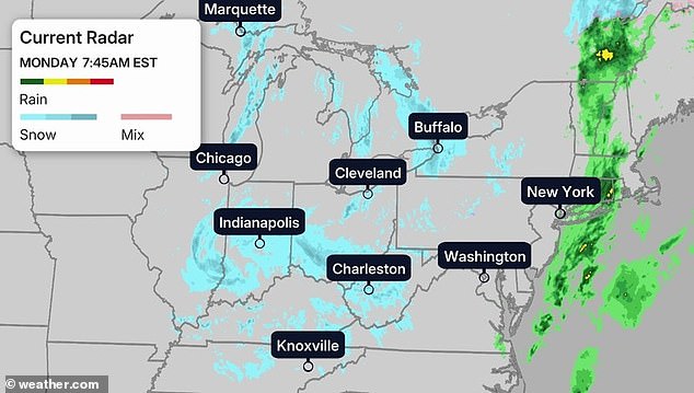
In addition to the extreme cold, the Arctic blast is followed by the first snow of the season in some regions. Snow is already falling from Michigan's Upper Peninsula to the Smoky Mountains, with icy air spreading deep into the South and East. Heavy lake-effect snow is piling up across parts of the Midwest and Great Lakes, while flurries stretch into the Appalachians, upstate New York, and northern New England through Tuesday.
One particularly fierce snowband dumped up to 12 inches of snow in just six hours over Momence, Illinois, a town about 50 miles south of Chicago. Elsewhere, as much as 18 inches was recorded in buried areas south of Marquette, Michigan, while up to 10 inches was recorded across Michigan's Leelanau Peninsula, just north of Traverse City.
Over the weekend, parts of northwest Iowa and southeast South Dakota also picked up around five inches of snow. Highs will stay stuck in the 30s across the southern Appalachians and in the 40s from the Northeast's I-95 corridor down through Alabama, Georgia, and Mississippi.
Cold weather advisories have been issued for most of Florida, extending as far north as Boca Raton, near the state's southern tip, just 45 miles from Miami.
Jonathan Porter, AccuWeather Chief Meteorologist, said: "This storm pattern will introduce some of the coldest air seen for early November, and that is the reason for the robust snow amounts expected in the Great Lakes and the far southern extent of the flurries into the southern Appalachians."
While the Chicagoland lake-effect snow is expected to taper off by midday, heavier snow in the Lake Superior and Michigan snowbelts, from Upper and Lower Michigan into northern Indiana, will continue until late tonight. Elsewhere, snow will shift southward through the Ohio Valley and Appalachians tonight. In the eastern Great Lakes, lake-effect bands could continue through Tuesday before possibly turning into brief lake rainbands on Wednesday.
In northern New England, rain could change to snow Monday night, with wrap-around snow lingering into Tuesday in some areas. The heaviest additional accumulations could occur in the lake snowbelts from northwest Pennsylvania and southwest New York, south of Buffalo, up to New York's Tug Hill Plateau, the Green Mountains of northern Vermont, and the Appalachians of West Virginia, where over six inches of snow is possible.
Several more inches could also fall across the Ohio Valley and western Great Lakes snowbelts, including Michigan, Indiana, Ohio, northern Kentucky, and the Smoky Mountains.