Storm Claudia to Drench Britain with Six Inches of Rain in 12 Hours
Storm Claudia to Bring Heavy Rain and Strong Winds to the UK
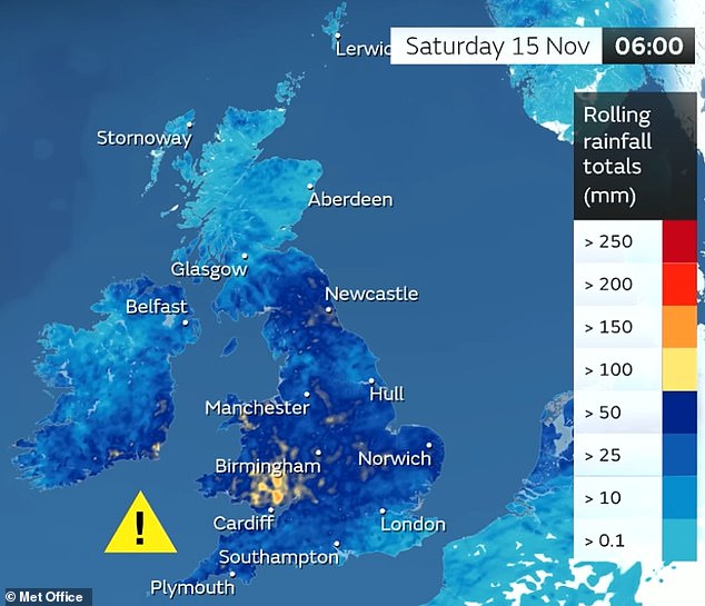
Storm Claudia is set to bring intense weather conditions to Britain, with up to six inches of rain expected in just 12 hours over the coming days. This has raised concerns about potential flooding and wind gusts reaching up to 70mph.
The Met Office has issued two 'danger to life' amber rain warnings for parts of central England and South Wales, which will be in effect from 12pm to midnight tomorrow. A broader and longer yellow rain warning has also been put in place for most of southern England and the Midlands, running from 6am tomorrow until 6am on Saturday. Additionally, two yellow wind warnings have been issued for parts of North West England and North West Wales, active from 12pm to midnight tomorrow.
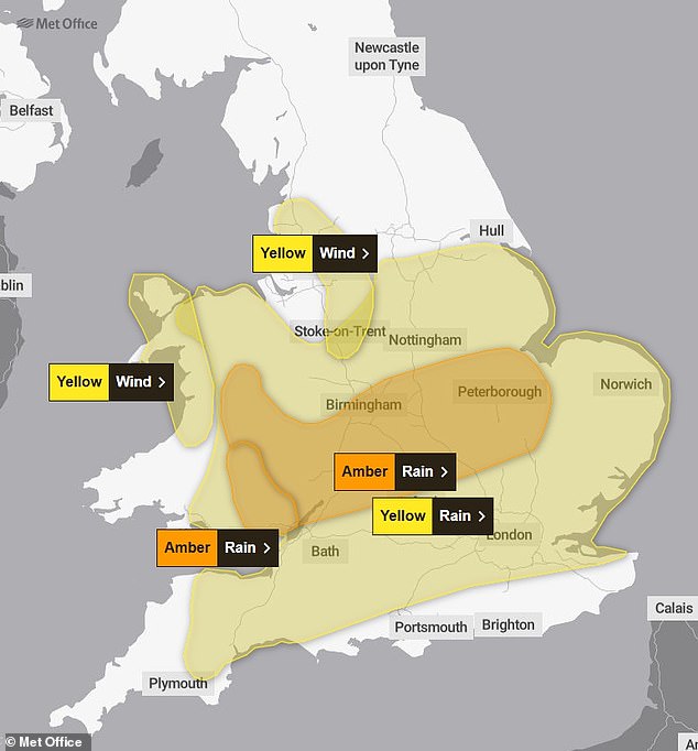
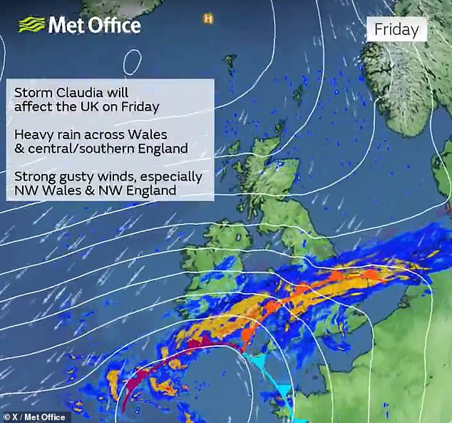
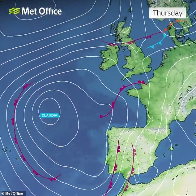
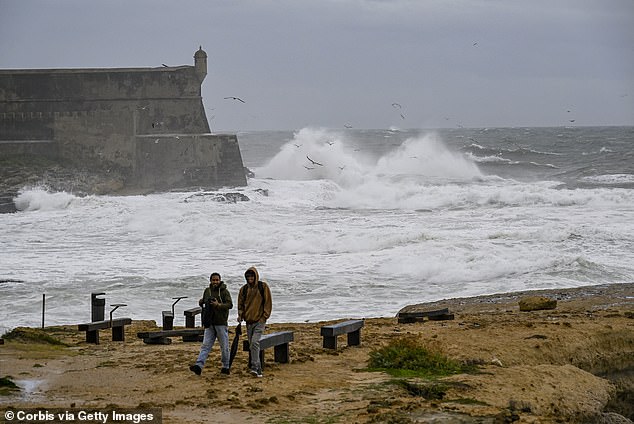
The storm, named in Spain where it is currently affecting western Iberia and the Canary Islands, is expected to bring prolonged heavy rain and strong easterly winds to the UK. South Wales is anticipated to receive the most rainfall, with 50mm to 75mm (3in) widely expected in the amber warning area, and 100mm (4in) to 150mm (6in) on some higher ground. The area of central England under the amber warning is expected to see 40mm (1.6in) to 60mm (2.4in) of rain, with some parts of the East Midlands, western England, and higher ground in Wales potentially receiving around 80mm (3.1in).
Forecasters have warned that travel disruptions could be worsened by strong easterly winds, with gusts of 50 to 60mph expected during the afternoon and evening. Up to 70mph is also possible over some exposed hilltops and coastal areas, while thunderstorms are expected later tomorrow afternoon and evening.
The amber warning for central England states that fast-flowing or deep floodwater is likely, posing a danger to life. It also warns of homes and businesses being flooded, leading to damage, difficult driving conditions, and potential road closures. Some communities may be cut off by flooded roads, and there is a good chance of delays and cancellations to train and bus services. Power cuts and loss of other services to some homes and businesses are also possible.
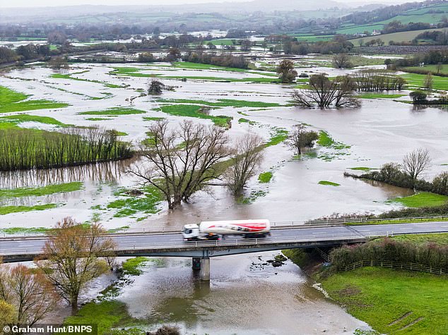
The amber warning for Wales is similar but includes an additional note that the loss of power and other essential services, such as gas, water, or mobile phone services, is possible. The Environment Agency has warned of local flooding from rivers and surface water, with 20 flood warnings and 35 flood alerts issued across England. Natural Resources Wales has issued eight flood alerts, while the Scottish Environment Protection Agency has activated two flood warnings and seven flood alerts.
Met Office chief meteorologist Matthew Lehnert stated that Storm Claudia will bring very heavy rainfall to a large swathe of central and southern England and Wales on Friday into Saturday. He added that this rain will become slow-moving, with some areas possibly seeing up to a month's worth of rain in 24 hours. Much of this will fall on saturated ground, increasing the chances of flooding and contributing to the amber warnings issued.
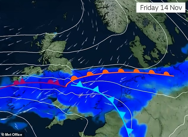
Although Storm Claudia will not directly cross the UK, it will be responsible for the heavy rain from tomorrow. The system is expected to largely maintain its position to the west of Britain, although the associated fronts will weaken through Saturday. By the weekend, the North of the UK will be under a colder air mass with overnight frosts, and it will be drier and brighter despite further showers.
In the South, the weekend will begin largely cloudy and wet, with mild conditions in the far south. The rain will gradually ease and eventually clear to the south, with drier and colder conditions further north affecting all parts by the start of next week.
Safety Measures for Motorists
The AA has urged motorists to take extra care when the warnings are in force. Shaun Jones, its roadside patrolman of the year, emphasized the importance of safety: "Reduce your speed, keep your distance, and avoid flooded roads completely. Conditions may change quickly, so stay updated and make sure you're prepared before you travel."
He added, "Flood water can appear quickly, and even shallow water can be dangerous – never try to drive through it. Stay tuned to local traffic updates and adjust your speed to suit the conditions. If your car starts to aquaplane, ease off the accelerator gently to regain control."
RAC breakdown spokesperson Alice Simpson said drivers should take the amber weather warnings associated with Storm Claudia extremely seriously, as they indicate roads are likely to become flooded and represent a risk to life. She advised drivers to consider delaying their journeys until the worst of the impacts are over, especially in areas hardest hit this weekend.
Preparing for the Weather
The Royal Society for the Prevention of Accidents urged the public to take extra precautions ahead of Storm Claudia. Steve Cole, the charity's policy director, said, "Storm Claudia isn't just a risk outdoors; homes may be vulnerable too. Secure garden furniture, bins, and anything that could blow away or cause damage. Indoors, make sure windows and doors are firmly shut and keep an emergency kit ready."
On the roads, he added, "Rain doubles stopping distances and aquaplaning can happen in seconds. Slow down, keep your distance, and never attempt to drive through floodwater. These simple steps can help protect your home, your journey, and keep communities safe."
Snowfall Expected Next Week
Britain is also preparing to face its first widespread snowfall since last winter as temperatures take a dramatic plunge from this weekend. Snow has already begun falling in parts of Scotland today, where people were photographed walking during flurries on Cairngorm Mountain in the Highlands.
By the middle of next week, conditions could be cold enough for the whole country to see snowflakes at times, according to ITV forecaster Laura Tobin. She said cold air would start to push down through Scotland and northern England from the weekend, with charts from the European Centre for Medium-Range Weather Forecasts (ECMRF) confirming snow was looking likely from Saturday.
Initially, there could be snow showers on Scottish hills, before more significant snowfall on Sunday in the Highlands and parts of northern England and Wales. Snow could again be seen in northern Scotland on Monday, before a pause on Tuesday. However, Ms Tobin said that on Wednesday, Thursday, and Friday, "for everybody next week there is a chance of seeing snowfall – it will be most significant across northern areas, but there's a chance of all of us seeing snow as we head into next week."